Another Batch of Adak Photographs
By Michael Gordon
Up One Level to Adak Selector
Not many places in the world like Adak. You either hate it (more common)
or love it (less common). Obviously, I loved it, at least at the time.
The pictures are scanned to fit a 1024x768 pixel screen, or smaller. Each
image is 40K to 120K in size. I made 9000 photographs, covering pretty much
all of Adak except extremo restricted areas which you weren't even supposed to
LOOK at -- ask LT Jim Bell who was jogging one evening in some pretty awful
weather (1977 I think, remember him? NOTHING would stop him from jogging --
not even a howling BRAVO weather condition, four-wheel drive only permitted on
the road weather condition! -- and they had almost kicked him out of the Navy
for swimming across, or wanting to swim across, or starting to swim across, a
shark-infested channel at Guam, which, as I recall the rumors right, he went
back there after getting out of the Navy and did it anyway) -- and suddenly
found himself face down in ice-cold water and mud surrounded by Marines with
rifles who considered it highly suspicious for anyone to be running all the
way round the ring road across Toothpick Bridge which was about to fall apart
anyway; and that whole episode made him late for a dinner party at Captain
MacCabe's house. Still, if I remember right, the Marines were kind enough to
give him a lift to the Captain's house whereupon he entered soaking wet in a
tank-top T-shirt despite being hardly above freezing outside.
Hmm, where's my Toothpick Bridge photo? It was a beautiful wooden trestle
bridge. Well, that's for later.
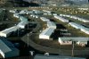
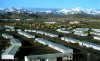 I'm in a hurry, so there's no particular theme to these pictures, I'll just
start somewhere; like maybe the same place that many of you start a day's
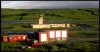
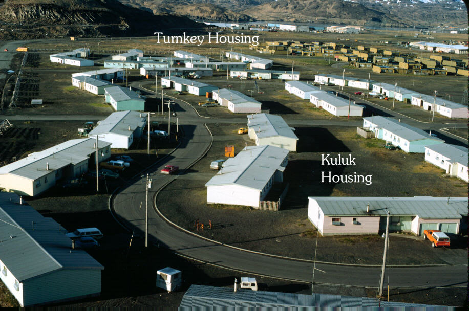
adventure, at home, perhaps in one of these houses: The first is showing Kuluk Housing looking south from Norpac Hill.
You can see some Turnkey housing too. The second one is looking
south-southwest, and includes Mount Reed in the distance on the right.
I'm in a hurry, so there's no particular theme to these pictures, I'll just
start somewhere; like maybe the same place that many of you start a day's
adventure, at home, perhaps in one of these houses: The first is showing Kuluk Housing looking south from Norpac Hill.
You can see some Turnkey housing too. The second one is looking
south-southwest, and includes Mount Reed in the distance on the right.
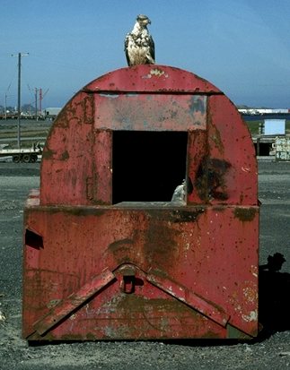
 Some
interesting things happened every day right near the houses; as for example,
ravens and eagles. They were smart enough, big enough, and strong enough
to get inside the dumpsters and throw out the trash. The ravens would get
inside, the eagles would stand on top and wait for something. The eagles were
more practical minded, interested only in food, but the ravens were looking
for entertainment as well as food, and shiny metal objects were very much in
demand.
Some
interesting things happened every day right near the houses; as for example,
ravens and eagles. They were smart enough, big enough, and strong enough
to get inside the dumpsters and throw out the trash. The ravens would get
inside, the eagles would stand on top and wait for something. The eagles were
more practical minded, interested only in food, but the ravens were looking
for entertainment as well as food, and shiny metal objects were very much in
demand.
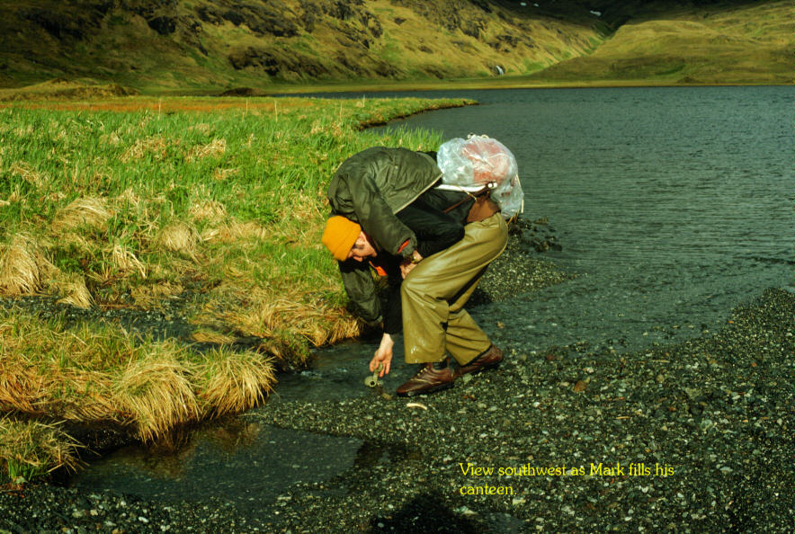
 Hiking and outdoors! Here is friend Mark fetching water from a
stream pouring into Lake Betty near its southeast boggy swampy part that was
so wet and squishy that it was preferred to walk on that very narrow strip of
gravelly "beach" surrounding the lake except where the lake was surrounded by
sheer cliffs, in which case you had to climb up rather high on wet slippery
grass and mud. As you remember, Lake Betty was the big lake that poured out
into Finger Bay, the stream of which was filled with very fine salmon every
August. The streams around Adak carried the best tasting, ice-cold water --
better than any other water any other place that I have been, before or
since.
Hiking and outdoors! Here is friend Mark fetching water from a
stream pouring into Lake Betty near its southeast boggy swampy part that was
so wet and squishy that it was preferred to walk on that very narrow strip of
gravelly "beach" surrounding the lake except where the lake was surrounded by
sheer cliffs, in which case you had to climb up rather high on wet slippery
grass and mud. As you remember, Lake Betty was the big lake that poured out
into Finger Bay, the stream of which was filled with very fine salmon every
August. The streams around Adak carried the best tasting, ice-cold water --
better than any other water any other place that I have been, before or
since.
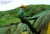 Gotta have a picture of me in here somewhere. Here I am
practicing rapelling on one of the quonset huts that had been revived,
reconstructed and rehabilitated, more or less, for recreational purposes. This
particular one I helped reconstruct for the local branch of The Church of Jesus Christ of Latter-Day Saints
and used the rope to climb up so as to apply tar on the roof seams. It was
also a fun thing to do. Outdoor stuff was my life; personal computers had not
yet been invented, so I read many science fiction magazines in the long winter
nights, but the long summer days were perfect for hiking.
Gotta have a picture of me in here somewhere. Here I am
practicing rapelling on one of the quonset huts that had been revived,
reconstructed and rehabilitated, more or less, for recreational purposes. This
particular one I helped reconstruct for the local branch of The Church of Jesus Christ of Latter-Day Saints
and used the rope to climb up so as to apply tar on the roof seams. It was
also a fun thing to do. Outdoor stuff was my life; personal computers had not
yet been invented, so I read many science fiction magazines in the long winter
nights, but the long summer days were perfect for hiking.
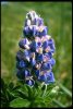

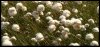
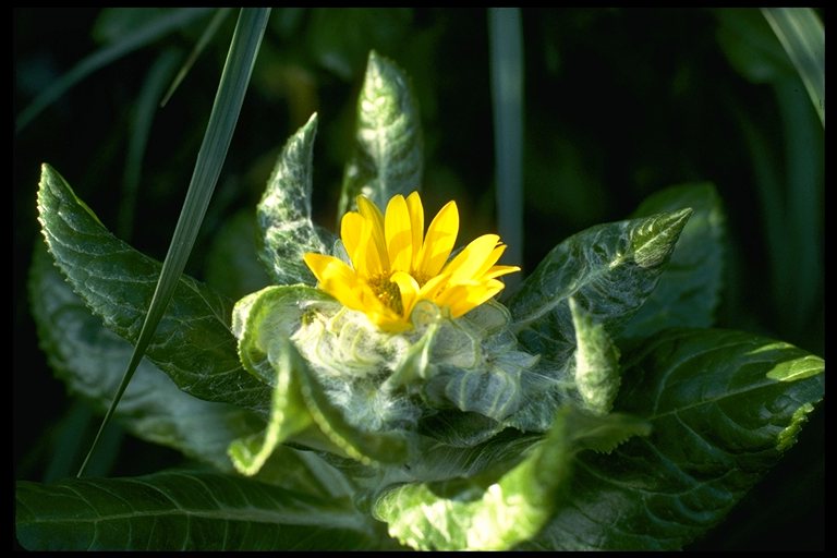
 Here are some flower and tree pictures. My favorite flower was
Lupine, an abundant plant at lower elevations. It was the most vibrant green
and dark blue color to be found. The bright yellow flower was as big as my
hand but I never did find out what it was; it grew near the beaches. The
wild cotton was abundant at 400 feet to 800 feet elevation. Tufts rolled
into your fist would keep your hand warm. The only trees were located at
the national forest. The national forest had been planted in 1954, a tree
for each state. Most of the trees survived over the years, and were very
fine, thick trees at least in the center of the grove, but not very tall.
Next to it on the west was the Pet Cemetary. Since then, new trees have
been planted by my friend Randy
but the weather is very bad and I don't know how many will survive.
Here are some flower and tree pictures. My favorite flower was
Lupine, an abundant plant at lower elevations. It was the most vibrant green
and dark blue color to be found. The bright yellow flower was as big as my
hand but I never did find out what it was; it grew near the beaches. The
wild cotton was abundant at 400 feet to 800 feet elevation. Tufts rolled
into your fist would keep your hand warm. The only trees were located at
the national forest. The national forest had been planted in 1954, a tree
for each state. Most of the trees survived over the years, and were very
fine, thick trees at least in the center of the grove, but not very tall.
Next to it on the west was the Pet Cemetary. Since then, new trees have
been planted by my friend Randy
but the weather is very bad and I don't know how many will survive.

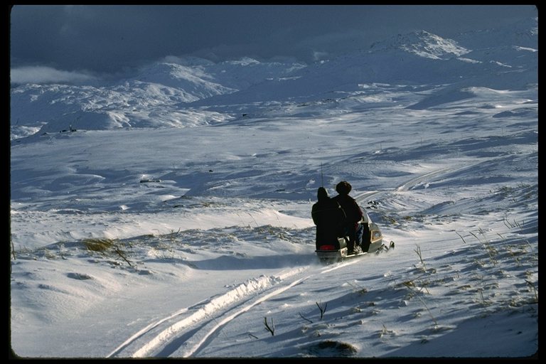
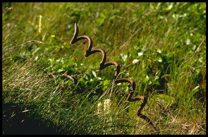
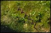 In the winter it was fun to go snowmobiling. Unfortunately,
station policy was fickle, some years it was permitted, some years not. But,
you had to watch out for spikes. The spikes were screwed into the ground
(they each have a long "auger" screw, which you see here turned upward) and
had two or three loops for holding barbed wire, then a sharpened point on top.
Over the years, the tundra grows up around them, and so you can be walking, or
worse, sliding down a hill (tundra sliding: fun, fast, wet; deadly if you
slide over a spike) or riding an inner tube behind a snowmobile and slide
across one of these things. Very dangerous.
In the winter it was fun to go snowmobiling. Unfortunately,
station policy was fickle, some years it was permitted, some years not. But,
you had to watch out for spikes. The spikes were screwed into the ground
(they each have a long "auger" screw, which you see here turned upward) and
had two or three loops for holding barbed wire, then a sharpened point on top.
Over the years, the tundra grows up around them, and so you can be walking, or
worse, sliding down a hill (tundra sliding: fun, fast, wet; deadly if you
slide over a spike) or riding an inner tube behind a snowmobile and slide
across one of these things. Very dangerous.
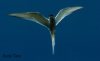
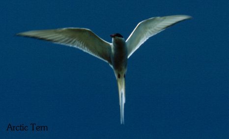
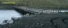 Other fun thing to do, get
dive bombed by Arctic or Aleutian Terns. The Arctic terns (pictured here)
stayed down around Candlestick Bridge also pictured here. As you can see,
the bridge was yellow-taped when I took this
picture because the engineers thought it was unsafe. Probably was, been there
a LONG time! However, folks put up a fuss, engineers may or may not have
reinforced the bridge, and eventually it was open. Or maybe someone just
peeled off the tape. Anyway, it did not fall apart in 1976 and it was still
there in 1987 and it's probably STILL there, with some gaping holes that you
can look down through and see otters, fish and seals. The water rushes in and
out really fast, filling and emptying Clam Lagoon with the tides. It's a great
fishing spot, by the way.
Other fun thing to do, get
dive bombed by Arctic or Aleutian Terns. The Arctic terns (pictured here)
stayed down around Candlestick Bridge also pictured here. As you can see,
the bridge was yellow-taped when I took this
picture because the engineers thought it was unsafe. Probably was, been there
a LONG time! However, folks put up a fuss, engineers may or may not have
reinforced the bridge, and eventually it was open. Or maybe someone just
peeled off the tape. Anyway, it did not fall apart in 1976 and it was still
there in 1987 and it's probably STILL there, with some gaping holes that you
can look down through and see otters, fish and seals. The water rushes in and
out really fast, filling and emptying Clam Lagoon with the tides. It's a great
fishing spot, by the way.
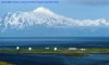
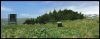
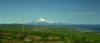
 Clam Lagoon and Great Sitkin Island photographs. First, an eastward
view overlooking the lagoon in the forground, bounded on
the far side by a narrow neck of land called Zeto Point, and on the other side
of that, Sitkin Sound, and 21 miles farther along is Great Sitkin Volcano.
Clam Lagoon and Great Sitkin Island photographs. First, an eastward
view overlooking the lagoon in the forground, bounded on
the far side by a narrow neck of land called Zeto Point, and on the other side
of that, Sitkin Sound, and 21 miles farther along is Great Sitkin Volcano.
By the way, these sunny pictures misconvey the usual
weather; Adak was usually AWFUL for weather and hardly ever changed -- lessee
if I can remember the usual weather. Wind 25-35 gusting to 45, temperature 40
degrees Fahrenheit, visibility 7 miles (sideways) and cloud cover beginning at
800 feet elevation, light rain and drizzle. This was what the weather was
about 300 days a year, with minor variations for temperature (winter was not
usually much below 30 above). Anyway, point is, so few days were sunny that I
could remember the date of every sunny day that had occurred in 2 and 1/2
years!
Zeto point has some eagle nests on it. Won't bother you with that right
here; I made 2,000 photographs of eagles while I was there and I have a
separate eagle page (http://www.orneveien.org/adak/eagles/index.htm).
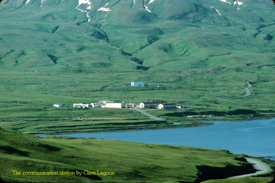
At the north end of the lagoon sorta on the west side of the north end is part
of a communication station, the receiving antennas (the transmit antennas were
located nearer to Adak town proper in order to better irradiate everyone but
maybe the receiving antennas were put out here so as to not listen to the
harmonics of everyone's television and microwave ovens!).
Behind it is Mount Adagdak

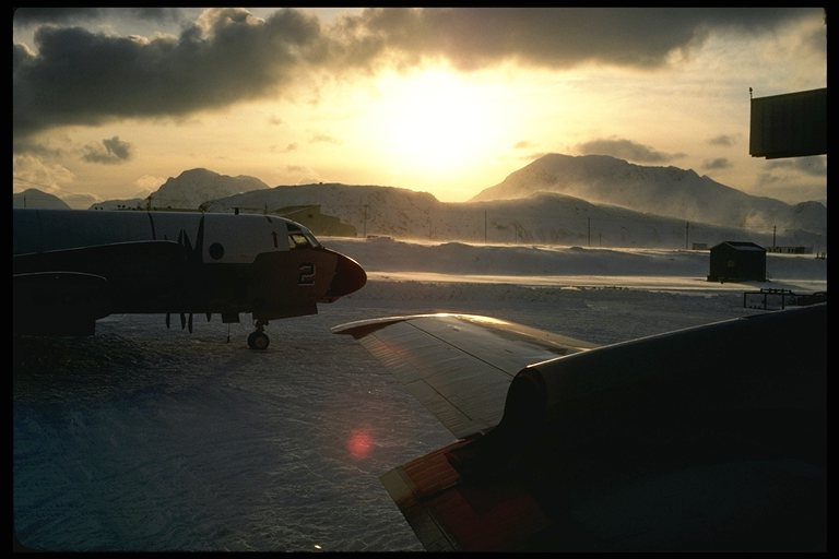
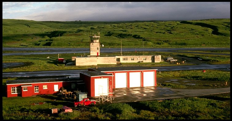
 Air Operations. This is one of the most
significant reasons for Adak to be here.
First, Sunrise over Monument Hill, as seen from the port overwing hatch on a
P3. Second, the air control tower. Third, Reeve Aleutian Airways (fondly
known as "Reeve Illusion Airways" locally; but they were sharp pilots and
can fly in just about any weather). Surveillance and rescue operations constituted most of the military
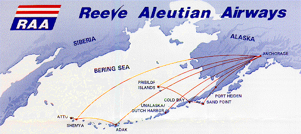
aircraft flights; the civilian flights were pretty much limited to Reeve Aleutian Airways (airmap) and, well, that's it; there was a weekly C-141
"Garbage Flight" carrying produce, which, because the bad weather made C-141's
unable to land and had to return to Elmendorf; by the time they DID land, part
of the cargo had been reduced to garbage. When I was there, two women fought
over the last watermelon in the commissary, and it broke in half as they
tugged on it, and both women cried real tears.
Air Operations. This is one of the most
significant reasons for Adak to be here.
First, Sunrise over Monument Hill, as seen from the port overwing hatch on a
P3. Second, the air control tower. Third, Reeve Aleutian Airways (fondly
known as "Reeve Illusion Airways" locally; but they were sharp pilots and
can fly in just about any weather). Surveillance and rescue operations constituted most of the military
aircraft flights; the civilian flights were pretty much limited to Reeve Aleutian Airways (airmap) and, well, that's it; there was a weekly C-141
"Garbage Flight" carrying produce, which, because the bad weather made C-141's
unable to land and had to return to Elmendorf; by the time they DID land, part
of the cargo had been reduced to garbage. When I was there, two women fought
over the last watermelon in the commissary, and it broke in half as they
tugged on it, and both women cried real tears.
 The other way cargo arrived
was on the Aleutian Developer. I developed a friendship with the chief
engineer, Willie Scales, a Hawaiian from Maui living in Idaho but working out
of Seattle. He needed an oilscreen for one of his engines so we went to an
old dump near Lake Andrew and rooted around until we found a stout piece of
heavy-gauge wire screen, and then returned to the ship with it. Since those
days, the dumps have all been buried so you cannot do it anymore, but in those
days, it was fun (and somewhat of a pestilence I suppose) to see what was at
the dumps. Many ancient decrepit buildings existed, too; in an old power
station we found an operations log, the pages were dated from 1951 or
something like that -- waterlogged, and covered by a plank (that's why no one
else found it). We carefully peeled the pages apart and I suppose I still
have some of the pages somewhere. At any rate, we made photographs but I
haven't found them yet for scanning. Later!
The other way cargo arrived
was on the Aleutian Developer. I developed a friendship with the chief
engineer, Willie Scales, a Hawaiian from Maui living in Idaho but working out
of Seattle. He needed an oilscreen for one of his engines so we went to an
old dump near Lake Andrew and rooted around until we found a stout piece of
heavy-gauge wire screen, and then returned to the ship with it. Since those
days, the dumps have all been buried so you cannot do it anymore, but in those
days, it was fun (and somewhat of a pestilence I suppose) to see what was at
the dumps. Many ancient decrepit buildings existed, too; in an old power
station we found an operations log, the pages were dated from 1951 or
something like that -- waterlogged, and covered by a plank (that's why no one
else found it). We carefully peeled the pages apart and I suppose I still
have some of the pages somewhere. At any rate, we made photographs but I
haven't found them yet for scanning. Later!
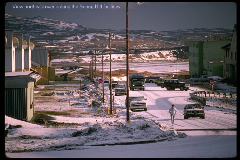
 Bering Hill was
entertainment center and home to many unmarried Adak residents. The Bachelor
Chief's Quarters were at the end of the row of barracks on the left (most
distant), in the center of those barracks was a chow hall (had various names
over the years, the fanciful "Enlisted Dining Facility" for a time and maybe
still) and nearest, but out of sight, the chapel. On the right, a large
building that had some rooms, but more importantly, it had the swimming pool,
movie theater, the "Tundra Tavern" operated by the Marines if I remember
right, (behind me on the right was the Husky Club, the Navy enlisted club).
It even had a pizza place and a genuine Baskin-Robbins® ice cream parlor!
One may wonder why we had ice cream when it was so cold and wet; well, you can
have cold and wet without sugar and spice outdoors, or WITH sugar and spice at
Baskin-Robbins! It may also do with humidity; the heating made the buildings
very dry, and the wet sweet taste of premium ice cream was appreciated any day
of the year. Oh yes, I should remember to mention, for your own frightful
recollection, the trouble one had getting DOWN off of Bering Hill in the
winter. No matter which of two roads you went down, the really steep curvy
one next to the women's barracks (should I say, a curvaceous road?) or the
slightly less steep, but perfectly straight road, either of them made a "T"
onto the ring road and it was not at all certain that you would be able to
stop. If the former, you'd slide right across the road into the power station
and laundromat (the hot water from cooling the engines assisted the boilers
for station heat and laundry); but if you slid across the road on the north
route, you'd end up in the ditch surrounding the runway.
Bering Hill was
entertainment center and home to many unmarried Adak residents. The Bachelor
Chief's Quarters were at the end of the row of barracks on the left (most
distant), in the center of those barracks was a chow hall (had various names
over the years, the fanciful "Enlisted Dining Facility" for a time and maybe
still) and nearest, but out of sight, the chapel. On the right, a large
building that had some rooms, but more importantly, it had the swimming pool,
movie theater, the "Tundra Tavern" operated by the Marines if I remember
right, (behind me on the right was the Husky Club, the Navy enlisted club).
It even had a pizza place and a genuine Baskin-Robbins® ice cream parlor!
One may wonder why we had ice cream when it was so cold and wet; well, you can
have cold and wet without sugar and spice outdoors, or WITH sugar and spice at
Baskin-Robbins! It may also do with humidity; the heating made the buildings
very dry, and the wet sweet taste of premium ice cream was appreciated any day
of the year. Oh yes, I should remember to mention, for your own frightful
recollection, the trouble one had getting DOWN off of Bering Hill in the
winter. No matter which of two roads you went down, the really steep curvy
one next to the women's barracks (should I say, a curvaceous road?) or the
slightly less steep, but perfectly straight road, either of them made a "T"
onto the ring road and it was not at all certain that you would be able to
stop. If the former, you'd slide right across the road into the power station
and laundromat (the hot water from cooling the engines assisted the boilers
for station heat and laundry); but if you slid across the road on the north
route, you'd end up in the ditch surrounding the runway.
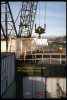
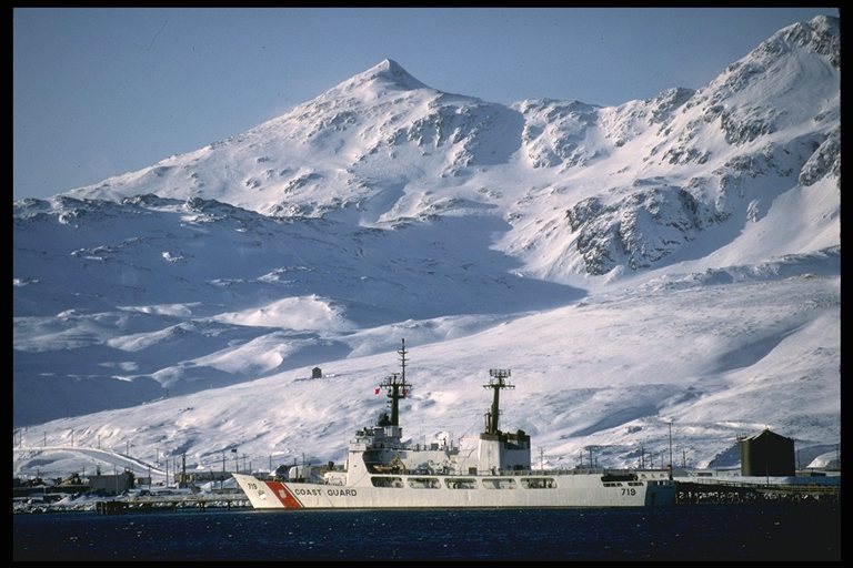
 Ships at sea!(Well, harbor). This occasional visitor, one of the beautiful gas-turbine
powered US Coast Guard cutters, stands out boldly on the dark blue water and
blue-white mountains. In this view, the ship is tied up at the fueling pier
at the south end of the runway in a body of water called "Sweeper Cove". We
are looking southwest toward Mount Reed, and at the foot of the mountains
exist two fairly large lakes, the upper is called Lake Bonnie Rose, and is the
lake from which the station draws drinking water, and the lower is called Lake
D'Marie, and has old waterworks since it was formerly the water supply for the
station. The upper left of the photograph shows Husky Pass, the way to reach,
on foot, the southwestern parts of Adak.
Ships at sea!(Well, harbor). This occasional visitor, one of the beautiful gas-turbine
powered US Coast Guard cutters, stands out boldly on the dark blue water and
blue-white mountains. In this view, the ship is tied up at the fueling pier
at the south end of the runway in a body of water called "Sweeper Cove". We
are looking southwest toward Mount Reed, and at the foot of the mountains
exist two fairly large lakes, the upper is called Lake Bonnie Rose, and is the
lake from which the station draws drinking water, and the lower is called Lake
D'Marie, and has old waterworks since it was formerly the water supply for the
station. The upper left of the photograph shows Husky Pass, the way to reach,
on foot, the southwestern parts of Adak.
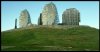
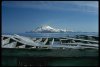
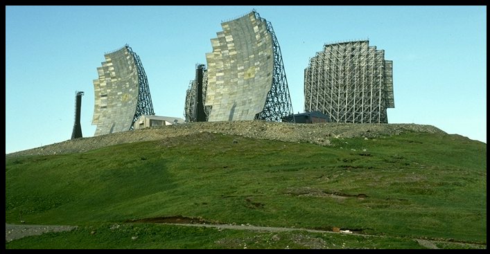
 Communications stuff. On
the left is the tropospheric scatter communications relay called "White
Alice." Satellites made it obsolete, there was no trace of it by 1987, just a
flat-topped hill where it used to be. The other photograph is looking east at
Great Sitkin island, and is significant more for the historical location on
the right of the original (1940's) Adak Town, as it is for the several antenna
towers. It would be rather boring except for it was a very pretty day, and
maybe you worked there and this brings back memories. I remember a
particularly severe late-autumn storm in 1978 that blew the big one down, and
volunteers were called for to put it back up, climb the tower and attach guys
and so forth. It sounded like fun but I'm not quite that brave or
athletic.
Communications stuff. On
the left is the tropospheric scatter communications relay called "White
Alice." Satellites made it obsolete, there was no trace of it by 1987, just a
flat-topped hill where it used to be. The other photograph is looking east at
Great Sitkin island, and is significant more for the historical location on
the right of the original (1940's) Adak Town, as it is for the several antenna
towers. It would be rather boring except for it was a very pretty day, and
maybe you worked there and this brings back memories. I remember a
particularly severe late-autumn storm in 1978 that blew the big one down, and
volunteers were called for to put it back up, climb the tower and attach guys
and so forth. It sounded like fun but I'm not quite that brave or
athletic.
Well, that's all for this batch! Watch for the next one.
 I'm in a hurry, so there's no particular theme to these pictures, I'll just
start somewhere; like maybe the same place that many of you start a day's
adventure, at home, perhaps in one of these houses: The first is showing Kuluk Housing looking south from Norpac Hill.
You can see some Turnkey housing too. The second one is looking
south-southwest, and includes Mount Reed in the distance on the right.
I'm in a hurry, so there's no particular theme to these pictures, I'll just
start somewhere; like maybe the same place that many of you start a day's
adventure, at home, perhaps in one of these houses: The first is showing Kuluk Housing looking south from Norpac Hill.
You can see some Turnkey housing too. The second one is looking
south-southwest, and includes Mount Reed in the distance on the right.


